I'll bet you thought I was on vacation! Oh, wait. I am on vacation. Anyway, I have been unable to blog for several days, because I have not had adequate access to the internet. So, I am hoping that my current setup will allow me to publish something fun.
When we last left our heroes, they were in Kalispell, MT. On Sunday, June 19, we departed Kalispell and made a beautiful drive along highway US2 to Sandpoint, ID. The drive took us through the mountains of northwestern Montana and beside some beautiful lakes. At Libby, we began to follow the Kootenay River, which is beautiful. (Gee it seems like I use that word a lot, but that is what happens when you tour the USA.)
US2 winds through the mountains in northwestern Montana.
The Kootenay River runs along the highway. These shots were taken near Libby, MT.
At last we arrived at Sandpoint, ID, a small town on the north end of Lake Pend Oreille. This is a huge lake carved out of the area by glacial action in the ice age. It is 1,180 feet deep! We continued on US95 to Sagle, ID, which is a small town about six miles south of Sandpoint, where we stayed at the Travel America RV Campground. The park is fairly nice, but the wi-fi was nothing but frustrating.
Here's our little abode in the Travel America RV Park in Sagle.
On Monday, we went into Sandpoint and checked out the shops downtown and the public beach, which is at a city park in the heart of town. It has sandy beaches and a protected harbor, where the locals moor boats by the dozens. Very nice. How we missed taking pictures there is anyone's guess.
Tuesday was our day to explore the east side of the lake. We drove to Hope, ID, population 89 and then on to East Hope, population 220. From there we took some side roads and found a resort called Beyond Hope! Lots of RV parks, State Parks and little harbors are to be found along this route. We stopped at the Floating Restaurant in East Hope and had lunch. The view of the lake was as good as the veggie and sausage soup we had.
One of the local residents near Beyond Hope.
The old blogger on the dock in front of the Floating Restaurant in East Hope.
We left Sagle, ID on Wednesday and traveled to Leavenworth, WA. The trip didn't offer too much variety of landscape until the very end. Most of eastern Washington State along I90 is either flatland with agribusiness or sagebrush, or it is rolling grassland, called the Palouse after the Palouse River which flows through the area. In turn, the river is named after an Indian people of the region.
The monotony of the landscape was broken up about halfway along our route by Moses Lake. I had heard of the city of Moses Lake for a long time, but this was my first time driving through. I said to Jill, "I don't know if there is a body of water called Moses Lake or just a town." Then we passed through the middle of a large body of water that seems to divide the town on a north-south axis that gave me the impression that the lake is roughly shaped like a figure of eight, with the town tucked into the space around the "waist" of the eight.
Eventually we came to the Wenatchee Valley. I had been there as a kid but had no recollection of it. It is a beautiful area covered with orchards and vineyards, nestled among the mountains, with the Wenatchee River running through the valley. Everywhere we looked there were fruit stands.
A few miles further along the road, we came to Leavenworth. This little town is nestled among some very steep-sided, craggy mountains that remind me of the Alps, which I had the good fortune to see about 30 years ago. The townspeople, some time ago, decided to redo the town as a Bavarian Village. The transformation is nearly universal among the buildings in the business section. It really does resemble a town in Bavaria. On the other hand, not all of the business owners, at least one restaurant owner, have been to Bavaria, judging by the soggy mess that we were offered, purporting to be Wiener schnitzel. So, bottom line, it is a cute little touristy town, but we agreed one visit is sufficient.
I took this one for our daughter, Tara, who is nuts about nutcrackers.
One of the many Bavarian style buildings.
Another shot for Tara.
More Bavaria!
The old blogger in the restaurant (which shall remain nameless) with the soggy Wiener schnitzel.
That being said, we did find a metal sculpture gallery that had some interesting pieces at very reasonable prices. We purchased a nice sculpture of a great blue heron for the chimney in our home.
Yesterday, we explored the Icicle River canyon, which runs up from the Icicle River RV Park, where we were camped for the last three days. The canyon is pretty steep, so the river runs very swiftly. There are numerous campgrounds in the area, many of them maintained by the forest service. There are also several very inviting private homes along the river.
The view from our table at Heidi's Kaffee Haus.
Note the interesting architecture in the background.
And check out the beautiful architecture on this one.
The building in the background is nice, too.
While we were at Icicle River, our next door neighbors were a couple named Norm and Joy. They are a bit older than we are, but they are full of vim and vigor. We enjoyed chatting with them, and they gave us some great tips about what to see and do in the area. They come to the area about twice a year, and they had been there about a week when we arrived. We bid them a fond farewell this morning and headed south on US97.
Our route today took us through Yakima, where my grandma lived all the time I knew her. I had looked up her address on Google maps, and her house is still there. It was actually a duplex, in which she rented an apartment. Oh how the memories of Grandma and my Auntie Faith and Uncle Walter came flooding back. Jill enjoyed learning a little more about my past life. If I recall correctly, I hadn't been to Yakima since 1978. It was a good stop.
Grandma lived in the right hand apartment, 203 1/2 S. 9th Avenue.
The yard has changed, but the house has not.
Heading west out of Yakima, we followed US12 as it winds through the Cascade Mountains. Halfway up the grade, we encountered Rimrock Lake, which is a rather large mountain lake with trees down to the shoreline and a number of campgrounds and hostelries along the highway. I told Jill to write it down on our "gotta look this one up" list. We may want to camp there some time. It would be a great place to take our kayaks.
US12 runs alongside the Tieton River. Jill loves the milky green color.
Here's a shot of Rimrock Lake. Note the same milky green color.
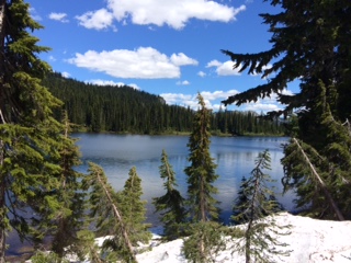
We kept on climbing past Rimrock Lake and passed Dog Lake, a smallish lake with a campground. Then we arrived at White Pass. This area is host to a great ski resort on the southern slopes of Mt. Rainier. I have skied there, but I have never seen it bare before. It seems smaller somehow, without snow all over everything.
Here is little Dog Lake.
Coming down the west slope of the Cascades the scenery continued to enthrall us. Finally we came to Packwood, WA, where we are camped for the next two days at the Packwood RV Park. We took a little stroll around the town, explored the local hardware store and stopped at the tourist info center and got a map of Washington State.
Majestic Mt. Rainier
Some other Cascade peaks on the way to Packwood.
This old log motel, across the street from the Packwood RV Park,
is abandoned now, but it must have been nice in its day.
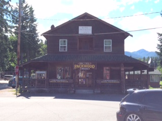
Here is the current Packwood Hotel, next door to the log motel.
Meet Virgil Jeffries, mayor of Packwood.
Tomorrow we hope to explore Mt. Rainier National Park.