Mount Rainier (pronounced: /reɪˈnɪər/), Mount Tacoma, or Mount Tahoma is the highest mountain of the Cascade Range of the Pacific Northwest, and the highest mountain in the state of Washington. It is a large active stratovolcano located 54 miles (87 km) south-southeast of Seattle. It is the most topographically prominent mountain in the contiguous United States and the Cascade Volcanic Arc, with a summit elevation of 14,411 ft (4,392 m).[4][5] Mt. Rainier is considered one of the most dangerous volcanoes in the world, and it is on the Decade Volcano list.[6] Because of its large amount of glacial ice, Mt. Rainier could potentially produce massive lahars that could threaten the entire Puyallup River valley.

Today's adventure was to drive the loop from Packwood to the Paradise Lodge in Mt. Rainier National Park and back. What a ride. Some of the roads and some of the views rivaled Glacier National Park...some of them.

Still, this was a trip well worth making, especially since my Senior Pass, purchased 8 years ago for $10, saved us $25 in entry fees. Skate Creek Road leaves Packwood near the east edge of town. It winds its way along the creek for several miles and climbs rapidly.
Finally, Skate Creek Road intersects with SR706, which leads into the National Park. Once inside the park, the road twists and turns like an angle worm on a hook. It also continues to rise, eventually coming to timberline and the Paradise Lodge. This being a warm Sunday in June, the road and especially the parking lot at Paradise was full of cars. In fact, the ranger at the park entrance was just putting out the sign about the full parking lot, when we arrived at the gate.
The Paradise Lodge looks quite lovely, and sits at timberline, with the snowy peak of the mountain in the background.


Since there was no parking available, we were unable to explore the lodge, but that was okay, because the mountain and the adjacent peaks and the rivers and lakes are so much more beautiful.


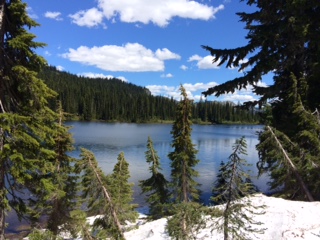
This is one of the mirror lakes.
The mountain top from the box canyon wayside.

We were in need of a comfort station, and as we emerged from a tunnel, I spotted one at the Box Canyon wayside. This area is wonderful. The tunnel is very rustic looking, as if it was blasted from solid rock.


And the bridge over Box Canyon is all made of stone. It looks like a WPA project.

But what really makes the area is the box canyon. Unfortunately, this is one of those places that cannot be captured on film, although I was willing to try. What looks like a narrow channel is actually parallel vertical walls about 100 feet high.

This sign is posted on the railing of the bridge.

The loop took about four hours to drive. It could have taken a lot longer, had there been less traffic and more available places to park and investigate. Still, we had a great time, worked in a picnic lunch and had the dogs out of their crates by 2 PM for a walk and "business" duties.
No comments:
Post a Comment